
Educational Outcomes:
Weather is the state of the atmosphere at a particular time and place, mainly with respect to its impact upon life and human activity. It is defined by the various weather elements including air temperature, humidity, cloudiness, precipitation, visibility, air pressure, and wind speed and direction. The surface weather map is a useful tool for depicting weather conditions over broad areas.
After completing this activity, you should be able to:
Before you begin this exercise, you will have
had to attend the "Weather Basics" discussion and should have read
Chapter
1 in the Online Weather Studies textbook (of if a
different
textbook is being used, the supplemental reading Weather Information
in your reference manual following the Weather Basics lecture
outline),
Z-Time
on Weather Maps, and Reading
the Surface Station Model and the assigned pages in the
textbook
on weather maps. You will also need the following images which
may
be downloaded and printed.
|
|
|
(print in landscape) |
(print in landscape) |
|
Before you begin this section, download and print the answer sheet. Unless told otherwise, put all your answers on this answer sheet.
1) Examine the surface weather map presented in Image 1. The weather symbols shown are those commonly seen on television and in newspaper. The H's and L's identify centers of relatively high and low air pressure compared to their surroundings. These pressure systems are commonly 500-1000 miles across. The "H" positioned in Texas locates the center of a high pressure system; atmospheric pressure increases horizontally inward toward this "H" and decreases horizontally outward away from the "H". Moving outward horizontally from the "L" located in lower Michigan, air pressure [ A) increases B) decreases ].
2) The thick curved lines on the map are air mass boundaries. In the atmosphere, broad expanses of air with generally uniform temperature, humidity, and density come in contact with other masses of air having different temperature, humidity, and density. Because air masses of different densities do not readily mix, the boundaries separating air masses tend to remain distinct. These boundaries, which are actually narrow zones of transition, called fronts, typically separate warm and cold air. The leading edge of advancing cold air is a cold front and, as shown in the lower part of Image 1, is signified by triangle symbols which are pointing in the direction toward which the cold front is moving. The leading edge of advancing warm air as it moves into a region of relatively cooler/colder air, is a warm front and is signified by semi-circles on the side of the front's forward movement. (a) The front in the Southeastern U.S. is a [ A) cold front B) warm front ]. (b) According to the map, persons living in South Carolina can expect [ A) colder B) warmer ] weather after the front passes.
3) Precipitation is depicted on weather maps by a variety of symbols including dots or periods for rain, horizontal lines for fog, and stars or asterisks for __________________ .
4) Make certain you have read the supplemental reading Reading the Surface Station Model . Refer to the model legend in Image 2 to interpret the following plotted data:
b) Wind direction is shown by the "arrow" shaft drawn into the circle representing the station. Unless otherwise noted, north is to the top on the page (map) and east is to the right. Wind is always named for the direction from which it blows. In the above depiction, the wind direction is from the _________________________.
c) Wind speed is rounded off to the nearest 5 knots and is symbolized by "feathers" drawn on the clockwise side of the wind-direction shaft. A full feather represents 10 knots (11.5 mph) and half feathers indicate 5 knots. A pennant indicates 50 knots and a circle drawn around the station circle signifies calm conditions. In this case, the reported wind speed is ____________ knots.
d) Air pressure (adjusted to sea-level) is reported as a coded number to the nearest tenth of a millibar (mb). To decipher the plotted pressure value, first place a decimal point between the second and third number from the left. Then add a "9" or "10" to the left so that the resulting number falls within the range of air pressures that commonly occur at sea level (usually between 960 mb and 1050 mb). For example, a plotted value of 126 represents 1012.6 mb and 863 denotes 986.3 mb. The air pressure reported above is ______________mb.
e) Sky coverage (total amount of cloud cover) is reported inside the station circle. An empty circle indicates no cloud, a half-shaded circle means four-eights of the sky is cloud-covered, and fully shaded circle stands for a completely overcast sky. The reported cloud cover is _________________ .
f) Current weather is plotted at the "9 o'clock" position on the station model (to the left of the station circle) using a variety of symbols representing the particular weather conditions. The reported current weather is ____________________ .
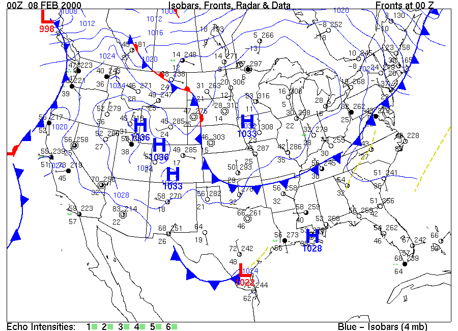
5) Click onto Image 3
which is the 00Z 08 FEB 2000 surface weather map. It depicted
weather
conditions across the country as a cooler continental polar air mass
moved
into central and eastern U.S. Ohio is in the eastern time
zone
of the U.S. and is five time zones west of the Prime Meridian.
Weather
observations for the entire map were taken at what local time and day
(date)
in Youngstown?
____________________________________________________________________________
6) The wind directions at stations in the central U.S. and Canada region around the high pressure center centered in Iowa generally showed the (a) [ A) clockwise B) counterclockwise ] and (b) [ A) inward B) outward ] circulation pattern typical of Northern Hemisphere high pressure systems.
7) At map time, St. Louis, on the eastern border of Missouri along the Mississippi River, had winds from the (a) ______________ at about 5 knots and the air pressure corrected to sea level was (b) __________________ mb.
8) At North Platte, in central Nebraska, the air pressure corrected to sea level was 1030.3 mb and at San Antonio, in south-central Texas, it was 1024.2 mb. (a) Which city, [ A) North Platte B) San Antonio ], was cooler? The dewpoint is the temperature to which air must be cooled (at constant pressure) to achieve saturation (100% relative humidity). The higher the dewpoint, the greater the concentration of water vapor in the air. (b) From the reported dewpoints, the air in [ A) North Platte B) San Antonio ] contained less water vapor. This is consistent with the Canadian air mass that is affecting the north-central and north-eastern United States.
9) The boundary of continental polar air moving out of Canada is shown by a heavy line (blue if in color) with triangles stretching from northeastern U.S. to northern Oklahoma. This line locates the position of a cold front. Greensboro in north-central North Carolina could expect [ A) cooler B) warmer ] temperatures in the next day or so.
10) Locate the "H" over Iowa. Moving
outward horizontally for several hundreds of miles from the "H", air
pressure
[
A) increases B) decreases ].
Hint: examine the pressure values displayed on the station models
located
progressively outward from the "H."
Questions 11-13 refer to the 20Z 27 OCT 1999 surface weather map (Image 4).
11) Centered over the Dakotas is a low pressure center on the 20Z 27 OCT 1999 surface weather map (Image 4). (a) Winds around this low pressure center are blowing in a [ A) clockwise B) counterclockwise ] manner. (b) These winds are blowing [ A) inward toward B) outward from ] the center of the low pressure system.
12) Extending toward the southeast from the "L" marking the center of the low pressure system over the Dakotas is a warm front. This front is indicated by a line (red if in color) with semi-circles that point in the direction that relatively warmer air is moving into a region of relatively cooler air. This front is moving toward the [ A) north-northeast B) south-southwest ].
13) Warm air can "hold" more water vapor than
cold
air. The relative humidity is a ratio that compares the water
vapor
content of the air with the air's water vapor capacity and is given as
a percentage. A parcel of air with a relative humidity of 60%
means
that the parcel is "holding" 60% of the water vapor it could hold at
that
given temperature. If the temperature and dew point are close
together,
the relative humidity is high. If the temperature and dew point
are
far apart, the relative humidity is low; that is because the
temperature
of the air parcel must be cooled quite a bit because it reach
saturation
(100% relative humidity). (a) Which location,
Nagagami,
north-northeast of Lake Superior or Key West at the southwest tip of
Florida,
experienced the higher relative humidity [ A)
Nagagami
B) Key West ] ? (b) Which location
is
actually "holding the greater quantity of water vapor within the air [
A) Nagagami B) Key West ]?
After downloading and printing, please put your answers on the
answer
sheet and only turn this sheet in on the due date. Late exercises
will NOT be accepted.
1 February 2002