| National Daily Weather Summary Text (USAT) | Current Nat'l Surface Analysis Map (TWC) |
| Meteorological Why of Current Wx Text (USAT) | Morning Nat'l Surface Forecast Map (TWC) |
| AMS DataStreme Nat'l Weather Summary (only during acad. term) | Midday Nat'l Surface Forecast Map (TWC) |
| Current Nat'l Surface Map w/ Radar (WSI) | Evening Nat'l Surface Forecast Map (TWC) |
| Current U.S. Surface Map w/ Radar Loop (WSI) | Next Day Evening Nat'l Surface Forecast Map (TWC) |
| U.S. 12-Hour Surface Forecast Map
(WSI) |
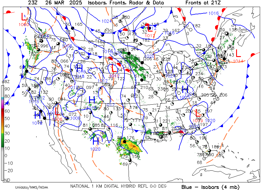
U.S. Surface Analysis Map w/ Isobars & Radar (AMS) |
| U.S. 24-Hour Surface Forecast Map
(WSI) |
U.S. Satellite Image & Surface Map (UNISYS) |
| U.S. 36-Hour Surface Forecast Map
(WSI) |
U.S Current Winds (WSI) |
| U.S. 48-Hour Surface Forecast Map (WSI) | |
| Today's U.S. Forecast High Temperatures Map (WSI) | National Forecast Summary (TWC) |
| Tomorrow's U.S. Forecast Low Temperatures Map (WSI) | |
| U.S. Precipitation Forecast Map (WSI) |
|
| U.S. Current Temperature Map (TWC) | U.S. Precipitation Forecast Probability Map (WSI) |
| Today's U.S. Forecast High Temperatures Map (WSI) | U.S. Rainfall Forecast Map (TWC) |
| Tomorrow's U.S. Forecast Low Temperatures Map (WSI) | U.S. Thunder Forecast Map (WSI) |
| Current U.S. 24-Hour Temperature Change Map (WSI) | U.S. Thunderstorm Forecast Map (TWC) |
| Current U.S. Windchill Map (WSI) | U.S. Snowfall Forecast Map (TWC) |
| Current U.S. Windchill Map (TWC) | U.S. 24-Hour Snow Forecast Mapt (WSI) |
| U.S. Windchill Forecast Map (TWC) | U.S. Snowcast Map (WSI) |
| U.S. Current Heat Index Map (TWC) | U.S. Observed Snow Cover Map (WSI) |
| U.S. Heat Index Forecast Map (TWC) | U.S. Previous Day's Precipitation Map (WSI) |
| U.S. 30-Day Temperature Outlook Map (TWC) | |
| U.S. 90-Day Temperature Outlook Map (TWC) | U.S. Dew Point Map (TWC) |
| U.S. 30-Day Precipitation Outlook Map (TWC) | |
| U.S. 90-Day Precipitation Outlook Map (TWC) | |
| U.S. Relative Humidity Map
(WSI) |
|
| Top of Page |
|
|
|
|
|
|
|
|
|
|
|
|
|
|
|
|
|
|
|
|
|
|
|
|
|
|
|
|
|
|
|
|
|
|
|
|
|
|
|
| UM Weather | UM Weather |
| WSI Intellicast | WSI Intellicast |
| CNN Weather | CNN Weather |
| The Weather Underground | The Weather Underground |
| OSU Weather By State (access to agricultural, climatic, observational, hydrometeorological, forecast, & model guidance data for all 50 U.S. states) | OSU Non-U.S. Weather Sites (provides forecasts, marine, & climatological data for selcted regions outside contiguous U.S.) |
| WeatherOnline |
|
| WWW Virtual Library: Meteorology (not available at this time) | UM Weather: WeatherSites |
| WWW Virtual Library: Government Weather Sites (not available) | UM Weather: N.A. WeatherCams |
| WWW Virtual Library: Meteorology - Schools (not available) |
|
| http://www5.ncdc.noaa.gov/pubs/publications.html
The National Climatic Data Center web address above has a number of online publications available free of charge to web users with .edu Internet addresses (there is a charge to other users). After placing your order, these Portable Document files (PDF) are immediately available for downloading using the Adobe Acrobat Reader. For educators and students with an .edu web address, make certain you click on the appropriate line: "FREE access by certain agencies and individuals (limited access only)" under each publication desired. The online NCDC document library publications listed to the right are available (to include climatological data for Ohio and other state & international stations): |
Monthly Climatic Data for the World
Storm Data Local Climatological Data, Edited Hourly Precipitation Data Climatography of the U.S. #81 - Monthly Normals Heating and Cooling Degree Day Data Climate Maps of U.S. Climates of the World Wind Climatology Freeze/Frost Data for the U.S. |
| WWW Virtual Library: Schools Offering Meteorology Degrees (U.S. and International) (not available at this time) | Pennsylvania State Univ. Dept. of Meteorology |
| Weather-Related Degree Programs (NSSL) | |
| Ohio State Univ. Atmospheric Science Program |
|
|
|
|
|
Last Revised: 01/29/07